
No products in the cart.


Roll over image to zoom in
Farmland Mapping Remote Sensing UAV XAG M2000 2022 Remote Sensing Drone,XMission drone VTOL UAV
R454,934 Excl VAT

![]() Pay over 3 EQUAL zero-interest
instalments of R151,645 with PayJustNow.
Pay over 3 EQUAL zero-interest
instalments of R151,645 with PayJustNow.
Find out how...
PayJustNow is a simple, easy-to-use payment system.
Here’s how it works:
PayJustNow allows you to pay for your purchase over 3 equal, zero interest instalments. You’ll pay one instalment at the time of purchase, the next at the beginning of the following month and the last one a month thereafter.
#zerointerest
Step 1:
Browse your favourite online stores and proceed to check-out.
Step 2:
Choose PayJustNow as your payment method.
Step 3:
Create your account as easily as if your eyes were shut (though we’d recommend you keep them open).
Step 4:
Complete your purchase and whoop for joy!
Here’s what you’ll need:
![]() A valid RSA ID document
A valid RSA ID document
![]() To be over 18 years old
To be over 18 years old
![]() An email address
An email address
![]() A SA Bank issued debit or credit card
A SA Bank issued debit or credit card
Product Description

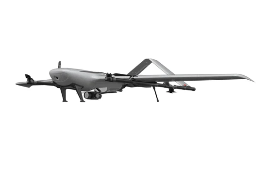

XAG m2000 Remote Sensing Drone
With the fixed-wing VTOL design, XAG M2000 Remote Sensing Drone is developed for high frequency and high
demand aerial survey tasks of multiple scenarios, which allows one person to map fields of 533 hectares in an hour¹.
Equipped with XAG SuperX 4 Pro Intelligent Control System, the XAG M2000 is capable of accessing quality
geographic data, which helps build up digital field maps stably and rapidly to facilitate production decisions.
Specification
|
item
|
value
|
|
Place of Origin
|
China
|
|
Hubei
|
|
|
Model Number
|
M2000 2022
|
|
Material
|
Plastic, Other, Rubber
|
|
Power
|
Electronic battery
|
|
Function
|
With Camera, With LED lights, with G-sensor, One Key Takeoff / Landing, APP Control, With Remote Control, Foldable
|
|
image capture resolution
|
|
|
Private Mold
|
NO
|
|
Operator Skill Level
|
Beginner
|
|
Control Type
|
Remote Control
|
|
image transmission distance
|
10KM
|
|
Indoor hover
|
40 minitues
|
|
Maximum Flight Time
|
30 minitues
|
|
Drone Type
|
app
|
|
Product name
|
XAG M500 2022 Remote Sensing Drone
|
|
Keyword
|
Remote Sensing Drone
|
|
Camera
|
4K HD
|
|
Type
|
Camera RC Drone
|
|
Feature
|
Remote Control Model
|
|
Color
|
White
|
|
Battery
|
lithium battery
|
|
Style
|
foldable
|
|
Flying time
|
35mins-40mins
|
|
Packing
|
Color Box
|
Additional information
| Weight | N/A |
|---|---|
| Color | White |
| Video Capture Resolution | Other |


Reviews
There are no reviews yet.